 Download 'Know before you go', our quick reference guide for recreational users of Port Taranaki and its approaches.
It covers safety requirements, speed restrictions, communications and radio channels, and much, much more. It's well worth having a copy with you on the boat!
MarineMate is a smartphone app that allows you to access information on tide times, boat ramp locations, VHF channels, and local boating rules for the whole country, all at the palm of your hand. Download it now!
Marine Mate for Android(external link) | Marine Mate for Apple(external link)
Watch the video to learn more about Marine Mate:
Heading out on the water? Take Marine Mate!
The Council's navigation & safety bylaws for Port Taranaki and its approaches aim to make this area safe for all users, commercial and recreational.
| Harbour areas | Recreational facilities | Speed restrictions |
The harbour limits for Port Taranaki and its approaches are defined by the sea area within a 2.5 nautical mile radius from Moturoa trig.

Port Taranaki and its approaches (click on map for large version).
The Port and its approaches have a wide range of users, from large merchant ships and domestic fishing vessels to recreational power boats, jet skis, yachts, kayaks, waka ama, paddle boards, distance swimmers, divers and beach-goers at Ngamotu Beach.
Harbour areas
The harbour can be a busy place, particularly in summer. To help ensure the safety of all users, it is divided into areas based on the risks associated with their use.
- Area A - Offshore covers the approaches to the Port and includes the Marine Restricted and Marine Protected Areas around the Ngā Motu/Sugar Loaf Islands and borders the Tapuae Marine Reserve to the west of the Harbour limits.
- Area B – Entrance is the only channel into the Port. It is a confined area bounded by shallows.
- Area C – Basin is protected from the sea by the Main and Lee Breakwaters but open to the effects of wind and sea. It is used as a turning area for most visiting ships which berth by the stern on Port Taranaki wharves.
The Basin is also a sheltered area for recreational activity where there is no five-knot speed restriction and the International Rules for the Prevention of Collision at Sea apply. - Area D – Berths presents specific hazards for ship manoeuvring and cargo operations. Access to this area by recreational craft and swimmers is prohibited.
- Area E – Inshore includes Ngamotu Beach, which is very popular in the summer as a swimming spot and for recreational maritime activity. It includes a boat access lane at its western end. A 5 knot restriction applies to all vessels in this area.

Port Taranaki & its approaches - Areas A to E (click on map for large version).
Recreational facilities
Recreational facilities at the Port include a public boat ramp and floating pontoon, and a car and trailer park at the eastern end of Area E (Inshore). Also at the eastern end is a boat mooring area with 33 privately owned buoyed moorings and a private marina. A vessel hardstand facility is available for use at low tide.
Please note: There are no fuelling facilities for recreational craft in the Harbour.
Area C (Basin) is a safe area within the shelter of the port breakwaters.

Children playing at Ngamotu Beach.
Speed restrictions & enforcement

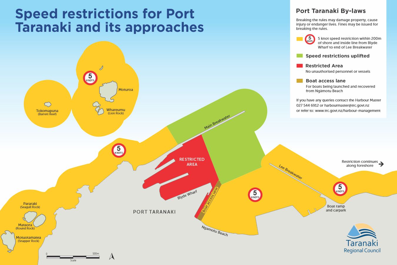
Speed restrictions at Port Taranaki and approaches.
The bylaws, reviewed in 2020, establish four zones:
- Reserve Area A (yellow on map) - where the 5 knot speed restriction applies. This provides a safe area off Ngamotu beach for swimmers and other recreational users, including the boat mooring area.
- Reserve Area B (green on map) - where the Maritime Rule Part 91 speed restrictions under clause 91.6(1)(b) are uplifted, allowing an area within the safety of the Port breakwaters for jets skiers, and power boats. The International Rules for the Prevention of Collision at Sea apply.
- Reserve Area C (red on map) - in the vicinity of the wharfs is reserved to ensure safe and efficient Port operations. Small craft and public cannot enter this area.
- Boat access lane (black on map) - an access lane at the end of Ngamotu Beach. A 5 knot speed limit must be observed by all vessels in this lane.
Organisers of temporary events can apply for temporary suspension of the bylaws. Please use our online application form for this purpose(external link).
As well as these harbour bylaws, the Council's Harbour Master and Deputy Harbour Masters may enforce all of the requirements of Maritime Rules Part 91 relating to things such as vessel speed, water skiing or towing, carriage of personal flotation devices and proximity to large cargo vessels, divers and swimmers within the harbour limits.
The Council’s bylaws also give the Harbour Master and Deputy Harbour Masters powers to stop a vessel. On presentation of a warrant, harbour users are required to provide their name and address, if asked.
Contact the Harbour Master on 027 353 3868 or email harbourmaster@trc.govt.nz.
Waters beyond the Port area
Coastal waters beyond those covered by the Council's navigation & safety bylaws, as well as estuaries, are the responsibility of Maritime New Zealand. For more information, email enquiries@maritimenz.govt.nz.